The 'bog standard' 3 Peaks of Yorkshire are Pen y Ghent, Whernside and Ingleborough and, each weekend, from May to September especially, loads (and loads) of walkers and charity walkers, and a fair few fell runners, trog round what is a fabulous 23 mile route. Its really well known and me, Harry and Hester have been round it loads of times and I suspect we will continue going round loads of times in the future too. The thing is though all of the Yorkshire Dales and all of the peaks in the Yorkshire Dales are just as fabulous and you could equally pick any set of 3 peaks in any 23 mile loop and have an equally great and/or epic time out going round them.
So its really brilliant that Upper Wharfedale Fell Rescue are staging a super tough 3 Peaks challenge of their own, but set in Upper Wharfedale, with their route covering the 3 peaks of Birks Fell, Buckden Pike and Great Whernside. They have organised a formal 22 mile race/event on 28th June (full details can be found here) and, if you're up to long distance hill running or hill walking and are in the area, why not give it a bash? They're also doing a shorter 13.5 mile 2 peaks challenge (Buckden Pike and Great Whernside) and an even shorter family 4.5 miler on the same day so pretty much all bases are covered. With all proceeds going towards the funding Upper Wharfedale Fell Rescue so what's not to like?
Anyway I've often run a loop of upper Wharfedale around Birks Fell, Buckden Pike and Great Whernside but my route has typically been a measly 16 mile version but, having got wind of the Wharfedale 3 Peaks Challenge, on Saturday me and Harry gave (our best guess of) the route a go. And we picked a really good day to give it a go too with the going being officially 'soft' and heavy showers blasting in for at least half the time we were out. It certainly felt harder than the 'bog standard' (easy peasy) 3 Peaks of Yorkshire!
Abso-fricking-lutely fan-blinking-tastic!
Harry already fannying about and we've only just started!
Leaving Kettlewell behind
Harry vaulting a stile with style
The trig point on Birks Fell
Harry galloping
The "path" was a "bit" muddy in places!
Yes... we were on the right track
It definitely took a stud
Descending Horse Head Moor to Yockenthwaite
Yockenthwaite ahoy!
Langstrothdale now and its looking good
A bubbling brook
The path was a bit more civilised at this point
Buckden Pike viewed through wind driven rain
We love mud!
Me and the boy on the way up Great Whernside
Okay the weather wasn't exactly brilliant at the top of Great Whernside!
Descending Great Whernside to Kettlewell - not far now


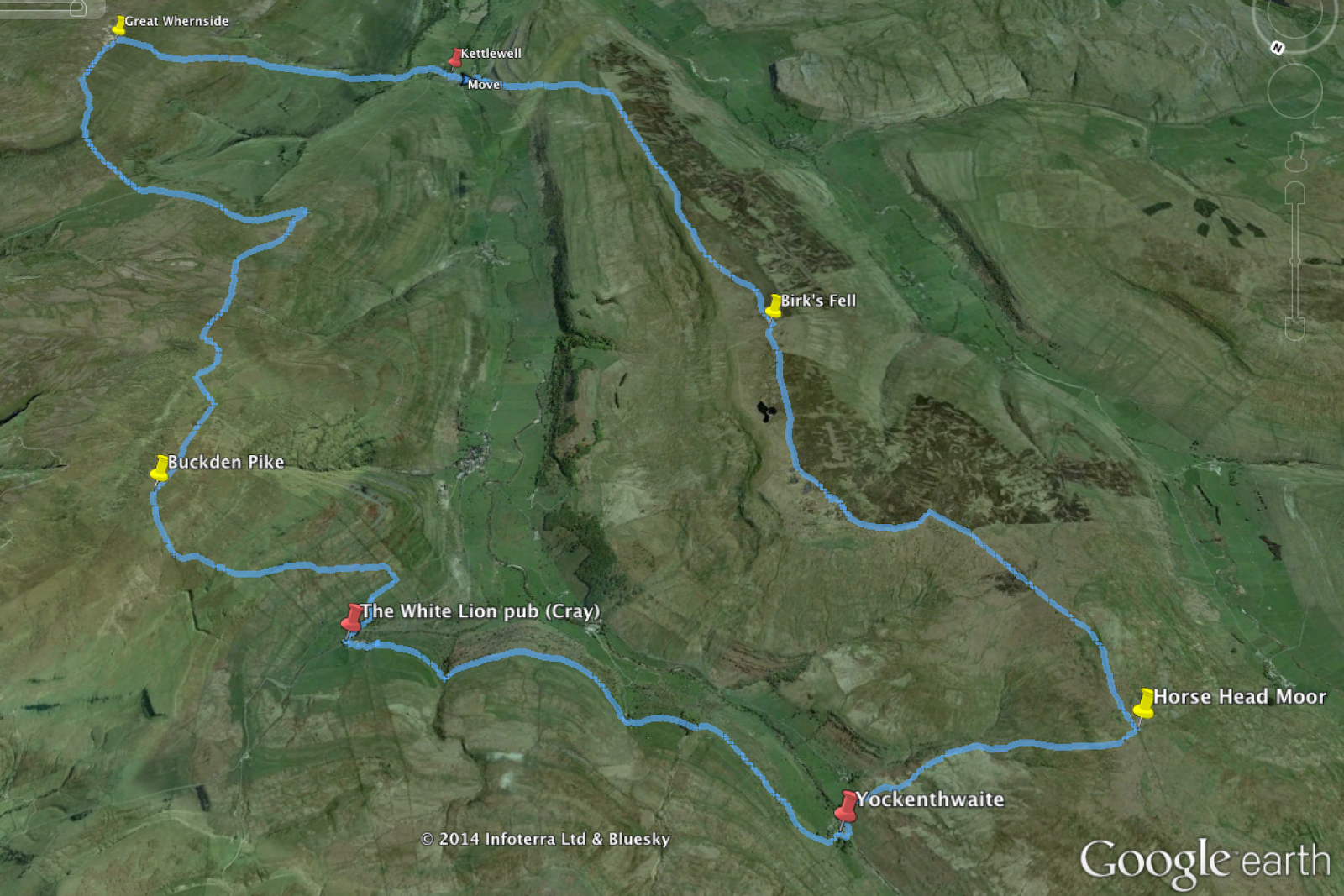
For the Google earth photo to match with the OS map it should really be turned 180 degrees or vice-versa.
ReplyDeleteThanks but I tend to put my google earth route views in whatever layout takes my fancy :)
ReplyDeleteDenizli
ReplyDeleteKonya
Denizli
ısparta
Bayburt
TKGYY
elazığ
ReplyDeleteerzincan
bayburt
tunceli
sakarya
88HO3
görüntülüshow
ReplyDeleteücretli show
K6İT
istanbul evden eve nakliyat
ReplyDeletebalıkesir evden eve nakliyat
şırnak evden eve nakliyat
kocaeli evden eve nakliyat
bayburt evden eve nakliyat
ZK8
BFA80
ReplyDeleteMardin Lojistik
Hatay Parça Eşya Taşıma
Urfa Lojistik
Kars Parça Eşya Taşıma
Bursa Parça Eşya Taşıma
71014
ReplyDeleteKarabük Evden Eve Nakliyat
Rize Evden Eve Nakliyat
Adana Parça Eşya Taşıma
Amasya Parça Eşya Taşıma
Kırıkkale Parça Eşya Taşıma
23BDD
ReplyDeleteAmasya Şehirler Arası Nakliyat
Zonguldak Lojistik
Trabzon Evden Eve Nakliyat
Malatya Parça Eşya Taşıma
Çerkezköy Parke Ustası
Kocaeli Evden Eve Nakliyat
İstanbul Lojistik
Nevşehir Evden Eve Nakliyat
Karaman Lojistik
E3B94
ReplyDelete%20 binance komisyon indirimi
160F0
ReplyDeletekayseri kızlarla canlı sohbet
sesli görüntülü sohbet
muhabbet sohbet
karabük bedava sohbet
muş rastgele canlı sohbet
mardin goruntulu sohbet
bilecik telefonda görüntülü sohbet
kastamonu en iyi sesli sohbet uygulamaları
bilecik mobil sohbet
0B380
ReplyDeleteKars Rastgele Sohbet Siteleri
kırşehir mobil sohbet odaları
sivas bedava sohbet odaları
yabancı görüntülü sohbet uygulamaları
balıkesir canlı sohbet siteleri ücretsiz
adana seslı sohbet sıtelerı
Muş Sesli Mobil Sohbet
canlı sohbet ücretsiz
batman telefonda kızlarla sohbet
E2105
ReplyDeleteStar Atlas Coin Hangi Borsada
Twitter Takipçi Satın Al
Binance Referans Kodu
Jns Coin Hangi Borsada
Caw Coin Hangi Borsada
Kripto Para Nasıl Üretilir
Coin Nasıl Çıkarılır
Ergo Coin Hangi Borsada
Satoshi Coin Hangi Borsada
27A69
ReplyDeleteMEME Coin Hangi Borsada
Facebook Sayfa Beğeni Satın Al
Bitcoin Nasıl Kazanılır
Binance Yaş Sınırı
Soundcloud Reposts Hilesi
Telegram Görüntüleme Satın Al
Okex Borsası Güvenilir mi
Binance Borsası Güvenilir mi
Caw Coin Hangi Borsada
BAF727822F
ReplyDeleteAnadoluslot
Anadoluslot Giriş Adresi
Anadoluslot Giriş Adresi
Anadoluslot Güncel Adres
Trwin
Trwin Giriş Adresi
Trwin
Trwin
Trwin
9BD1054161
ReplyDeletetakipçi satın al
Erasmus Proje
MMORPG Oyunlar
Binance Referans Kodu
Kazandırio Kodları
Raid Promosyon Kodu
Dragon City Elmas Kodu
M3u Listesi
Pasha Fencer Hediye Kodu
76BDCDE0DE
ReplyDeletegerçek takipçi
PK XD Elmas Kodu
Free Fire Elmas Kodu
Kazandırio Kodları
Stumble Guys Elmas Kodu
Razer Gold Promosyon Kodu
Yalla Hediye Kodu
Call of Dragons Hediye Kodu
Happn Promosyon Kodu
21D7E2BEEE
ReplyDeleteinstagram çok ucuz takipçi
tiktok beğeni satın al
ig takipçi
gerçek takipçi
düşmeyen takipçi
596DF83321
ReplyDeleteen iyi mmorpg oyunlar
sms onay
mobil ödeme bozdurma
takipçi satın alma
-
شركة تنظيف خزانات بابها
ReplyDelete7TMnC